Tokyo's latest flood map puts a third of city in risk zone

On March 30, the Tokyo Metropolitan Government issued a new flood map based on a super typhoon hitting the nation’s capital. Approximately a third of Tokyo’s 23 wards, representing 212 square kilometers, could be at risk of being flooded by a storm surge. Almost all of the flood risk zones are located in the eastern part of Tokyo which is a low-lying district. Central Tokyo, with the exception of some of the waterfront districts, and the western side of Tokyo is on elevated ground and outside of the risk area.
If levees are breached, some areas in eastern Tokyo could see flood waters with a depth of over 50cm covering an area up 84 square kilometers for a week or longer. The maximum flood depth could exceed 10 meters in some zones. Sumida and Koto wards could see an average flood depth of around 7 meters.
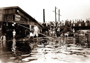
The 1 in 1,000 ~ 5,000 year worst-case flooding scenario is based on the scale of the 1934 Muroto Typhoon that made landfall in Muroto, Awaji Island and Kobe. It caused tremendous damage in Osaka. Over 3,000 people lost their lives and 200,000 were left homeless. The typhoon brought a tide of 3 ~ 4 meters which inundated 49 square kilometers of Osaka City. The simulation is also based on the speed of Typhoon Vera, or the Isewan Typhoon, which struck the Tokai region in 1959.Read more
